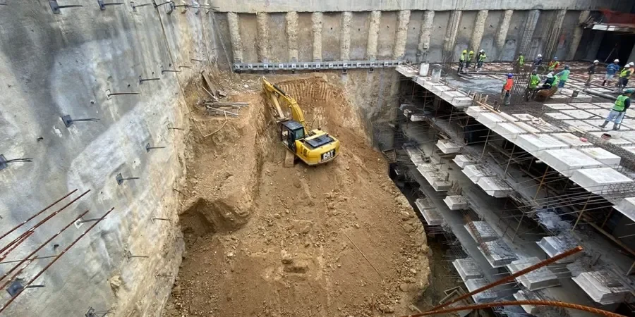
A contractor working on a new mixed-use development near the Canalside Quarter recently encountered ground conditions that challenged the initial earth retention scheme. The excavation, cut to just over eight metres for a double-level basement, passed through weathered sandstone and glacial till with perched groundwater. In Wolverhampton, projects like this reveal how quickly a deep dig can shift from routine to high-risk. The Triassic sandstones of the Sherwood Group, which underpin much of the city centre, offer good bearing but unpredictable fracture zones. Our team supports developers, contractors, and consulting engineers by producing geotechnical design of deep excavations that accounts for these local subtleties. From soil-structure interaction models to monitoring thresholds, the approach must be rooted in site-specific data. Too often, standardised solutions fail here because the transition from stiff clay into weathered rock creates abrupt changes in lateral pressure. A well-calibrated ground model, informed by exploratory boreholes and laboratory testing, makes the difference between a controlled dig and a costly delay.
In Wolverhampton, the biggest challenge in a deep excavation isn't depth. It's managing the transition from stiff clay into fractured sandstone without triggering unexpected collapse.
Method and coverage
Regional considerations
The West Midlands weather adds a layer of complexity that cannot be understated. Wolverhampton sees around 750 mm of rainfall annually, with heavy frontal systems in autumn that quickly saturate the upper drift deposits. A deep excavation left open during a wet October can degrade from a stable working platform to a safety hazard in a matter of hours. The stiff clays of the Wilden Formation are especially vulnerable; their intact strength is high, but repeated wet-dry cycles reduce the effective cohesion at the face. In the sandstone to the north, the risk shifts to rapid inflow through open joints, which can destabilise the toe of a cut. We integrate weather-triggered action plans into the temporary works design, specifying when additional support or localised grouting must be deployed. Another regional risk is the legacy of shallow coal workings along the eastern edge of the city: even when outside the mapped extraction zone, old shafts and adits can provide pathways for water or gas migration into an excavation.
Standards that apply
BS EN 1997-1:2004 (Eurocode 7: Geotechnical design – General rules), BS 5930:2015 (Code of practice for ground investigations), CIRIA C760 (Guidance on embedded retaining wall design), CIRIA C517 (Temporary works and the CDM Regulations), BS EN 1993-5:2007 (Eurocode 3: Design of steel structures – Piling)
Complementary services
Ground Model and Parameter Selection
Synthesis of borehole logs, in-situ tests, and laboratory data into a three-dimensional geotechnical model. We focus on the spatial variability of the Wilden Formation and Sherwood Sandstone contact, a critical interface in many Wolverhampton digs.
Retaining Structure Design (Walls and Props)
Analysis and detailing of embedded walls (secant, contiguous, sheet pile), strutting layouts, and waler systems. Design is checked for ULS, SLS, and accidental load cases including floodwater surcharge.
Construction Support and Monitoring Review
On-call review of excavation sequencing, interpretation of inclinometer and piezometer data, and adjustment of design assumptions based on observed ground behaviour during the dig.
Typical parameters
Top questions
What is the typical cost for a deep excavation design in Wolverhampton?
For a single basement or shaft design in the Wolverhampton area, the fee typically ranges from £1,620 to £7,000, depending on the complexity of the ground model, the number of construction stages, and the proximity of sensitive structures. A straightforward cut in competent sandstone with simple propping will be at the lower end, while a deep excavation in mixed ground with anchored walls and extensive groundwater control will require more analysis and sits at the upper end.
How do you address the risk of old mine workings during excavation design?
Wolverhampton lies on the fringe of the South Staffordshire Coalfield, so we always commission a mining report from the Coal Authority as part of the desk study. If shallow workings are suspected, we specify rotary drilling with downhole inspection to locate voids, and incorporate a grouting or capping strategy into the temporary works design to prevent sudden collapse or gas ingress.
Which retaining system is most suitable for Wolverhampton sandstone?
In the Sherwood Sandstone of central and northern Wolverhampton, secant or contiguous bored pile walls are often the best choice. The rock is strong enough to form a stable borehole wall, and the pile toe can be founded into the sandstone to provide vertical load capacity. Sheet pile walls are generally harder to install in dense rock and are more common in the softer alluvial and glacial deposits near the river valleys.
Can you handle the CDM 2015 Principal Designer role for the excavation?
Yes. Our team can act as Principal Designer under the Construction (Design and Management) Regulations 2015 for the geotechnical temporary works. We manage the pre-construction information, identify significant risks such as groundwater inflow or face instability, and coordinate with the permanent works designer to ensure the excavation sequence is safe and buildable.