Wolverhampton's development from a Saxon market town into a Victorian industrial powerhouse left a complex legacy beneath the streets. The city sits on Triassic sandstone and conglomerates of the Sherwood Sandstone Group, but centuries of mining, iron smelting, and canal building mean the near-surface geology is rarely straightforward. Our lab processes dozens of samples each month from sites across the West Midlands, and the first thing any contractor or consultant needs is a reliable particle size distribution. Whether it's glacial till near Tettenhall or weathered sandstone in Bilston, the atterberg limits and grain size curve together tell you more about behaviour than a borehole log alone. We run the full hydrometer analysis when fines content exceeds 10%, because skipping the silt-clay fraction in Wolverhampton's mixed soils leads to misclassifications that cost money later.
The hydrometer reading at 4 minutes, not 2 minutes, is what catches most technicians off guard with Wolverhampton's micaceous silts.
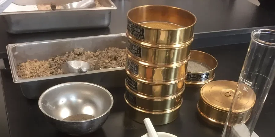
Method and coverage
Regional considerations
BS 5930:2015+A1:2020 is explicit about soil description for engineering purposes, and Wolverhampton's variable drift deposits make visual classification alone unreliable. The risk is misidentifying a clayey sand as a sandy clay, or vice versa, which cascades into wrong bearing capacity assumptions, incorrect earthworks specifications, and drainage failures. Sites on the Coal Measures outcrop can contain weathered mudstone that slakes during standard preparation; we identify these with the sedimentation curve showing an unusual bimodal distribution. For consultants working on brownfield redevelopment in areas like Wednesfield or Heath Town, where made ground contains brick fragments, ash, and clinker, the sieve analysis quantifies the oversize fraction that BS 5930 requires you to report separately. Without that number, the slope-stability assessment for an adjacent cut is based on assumed, not measured, grading.
Standards that apply
BS 1377-2:1990 — Methods of test for soils for civil engineering purposes: Classification tests, BS EN ISO 17892-4:2016 — Geotechnical investigation and testing: Determination of particle size distribution, BS 5930:2015+A1:2020 — Code of practice for ground investigations
Complementary services
Combined sieve and hydrometer analysis
Full particle size distribution from 75 mm down to 2 microns, covering the complete gravel-sand-silt-clay range in a single report with grading curve and all BS 1377 parameters.
Wash sieving and fines determination
For coarser soils where only the percentage passing 63 μm is needed, we run wet sieving with oven-dried mass comparison, often paired with sand equivalent testing for road subbase materials.
Expedited grading for earthworks QA
Same-day or 24-hour turnaround on sieve analysis when compaction verification is held up waiting for a grading curve. We prioritise these samples without sacrificing the washing stage.
Typical parameters
Top questions
How much does a grain size analysis with hydrometer cost for a Wolverhampton sample?
For a combined sieve and hydrometer test on a single sample from a Wolverhampton site, the fee ranges between £80 and £130 depending on the maximum particle size and whether you need the full sedimentation curve or just the silt-clay split. Multiple samples from the same project attract a reduced per-sample rate.
Why do I need the hydrometer part if the soil looks sandy?
Because the Sherwood Sandstone-derived soils around Wolverhampton often carry a silt fraction that is invisible to the naked eye but makes up 10-20% of the mass. That silt fraction controls permeability, frost heave potential, and how the soil compacts. Without the hydrometer sedimentation data, the grading curve stops at 63 microns and you lose the classification precision that BS 5930 demands for most foundation and earthworks designs.
How should I sample soil for a grain size test?
You need a disturbed bulk sample, not a core. For fine and medium-grained soils, 1 kg in a sealed plastic bag is sufficient. If the material contains gravel, increase that to at least 3 kg so we have enough for riffle splitting. Label the bag with project name, borehole or trial pit reference, depth, and date. Keep it at its natural moisture content if possible—though we oven-dry before testing, knowing the field moisture helps us spot anomalies in the fines behaviour early.