Wolverhampton’s development from a Saxon market town into a Victorian industrial powerhouse left a distinct geotechnical footprint. The city sits on the South Staffordshire Coalfield, where extensive mining and the excavation of railway cuttings through the New Red Sandstone created slopes that still require careful management today. The Middle Coal Measures and overlying glacial till across areas like Tettenhall and Penn often present a weathered mantle over competent rock, a condition that demands rigorous slope stability evaluation before any construction near an incline. Our team applies BS EN 1997-1:2004 Design Approach 1 to assess both short-term undrained and long-term drained conditions, ensuring that housing schemes on the city’s western fringes or infrastructure works along the Birmingham Canal corridors are supported by defensible factors of safety. When the site investigation reveals complex stratigraphy, we integrate test pits to physically log the shallow weathering profile and confirm the depth to the sandstone bedrock, a step that refines the input parameters for any subsequent limit equilibrium model.
In Wolverhampton’s Mercia Mudstone, the drained friction angle can drop below 22° after seasonal wetting, a detail that makes back-analysis of existing cuttings essential before any new construction.
Method and coverage
Regional considerations
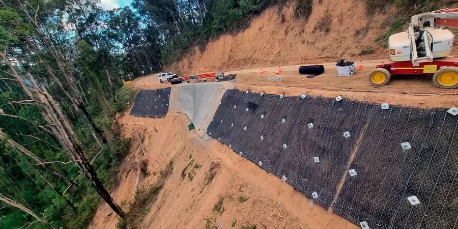
The West Midlands experiences a distinct rainfall pattern: moderate but persistent precipitation throughout the year, with autumn and winter storms delivering intense events onto already saturated ground. This hydrological regime, combined with Wolverhampton’s legacy of unrecorded shallow coal workings and the swelling-shrinking behaviour of the surface clays, creates a risk profile where slope failures often initiate as progressive, rather than sudden, movements. A cutting that has stood for eighty years can begin to show tension cracks after just one wet season if the toe drainage has been compromised. Our analyses explicitly model the loss of suction in the upper two metres of the profile, a mechanism that the standard limit equilibrium approach alone can miss. Where we identify a marginal factor of safety, we often recommend anchors as a remedial measure, designing the bonded length to extend beyond any potential slip surface identified in the sensitivity analysis.
Standards that apply
BS EN 1997-1:2004 Eurocode 7 – Geotechnical design – Part 1: General rules, BS EN 1997-2:2007 Eurocode 7 – Geotechnical design – Part 2: Ground investigation and testing, BS 5930:2015 Code of practice for ground investigations, CIRIA C580 – Embedded retaining walls – guidance for economic design, BS EN 1998-1:2004 Design of structures for earthquake resistance
Complementary services
Limit equilibrium and FE analysis for natural slopes
We build detailed cross-sections from borehole logs and geophysical profiles, then perform both limit equilibrium (Spencer, Morgenstern-Price) and finite element strength reduction analyses. Each model incorporates pore pressure distributions calibrated against standpipe and piezometer readings taken across the site, and the output includes a sensitivity study on the drained shear strength parameters to support the geotechnical design report.
Remedial design for railway cuttings and quarry faces
For slopes adjacent to railway lines or within former quarry workings, we design soil nailing, ground anchor systems, and regrading schemes that meet Network Rail standards. The design process includes a back-analysis of any existing failure scarps to constrain the in-situ strength envelope, followed by a staged construction sequence modelled to confirm stability at each excavation step.
Typical parameters
Top questions
What triggers a slope failure in Wolverhampton’s geology?
The most common trigger across the West Midlands is prolonged rainfall followed by a heavy storm event. Water infiltrates the weathered zone of the Mercia Mudstone or the glacial till, reducing the matric suction and lowering the effective stress. In areas with former mining, the collapse of shallow abandoned workings can also initiate a crown failure that propagates upslope. Our investigations always include a review of the Coal Authority’s mining reports to rule out this mechanism.
How long does a slope stability analysis take for a residential plot?
For a single residential plot near an existing slope in Wolverhampton, the field investigation typically takes two to three days, including dynamic probing and trial pitting. The laboratory testing programme runs for approximately four weeks to complete the triaxial and classification tests. The analysis and reporting phase then requires another two weeks, meaning the total turnaround from instruction to final report is usually six to seven weeks, assuming reasonable weather during the fieldwork.
What does a slope stability assessment cost in Wolverhampton?
A comprehensive slope stability analysis in the Wolverhampton area, including a ground investigation with dynamic probing, trial pits, laboratory triaxial testing, and a full limit equilibrium or finite element report, typically ranges from £920 to £3,550. The final cost depends on the slope height, the number of geological units present, and the access constraints on site. We provide a fixed-price proposal after an initial desk study and site walkover.