A Midlands contractor recently lost six weeks on a brownfield site near Wednesfield because the foundation design assumed a B site class based on a neighbouring plot. The actual ground, a mix of Coal Measures mudstone and buried alluvial pockets, produced a VS30 profile that fell firmly into category C. That single oversight triggered a redesign of the piling layout and pushed the project over budget before a brick was laid. Wolverhampton sits on a geological transition where Pennine Lower Coal Measures meet Quaternary drift deposits; the stiffness contrast between the two can exceed 200 m/s across less than thirty metres of lateral extent. A surface-wave approach like MASW resolves that contrast without drilling through weathered mudstone to refusal, giving the structural engineer a defensible VS30 value that reflects the real stratigraphy, not an assumption inherited from a desk study. When the foundation period depends on ground stiffness at depth, we often pair the acquisition with a targeted CPT test to calibrate the shear-wave data against measured tip resistance in the upper fifteen metres.
A single MASW line across a Wolverhampton brownfield lot can shift the seismic site class from C to B, and that one-letter change often saves more than the cost of the survey in foundation concrete alone.
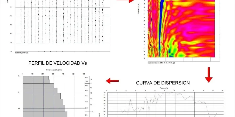
Method and coverage
Regional considerations
Sites in the city centre and sites in the western suburbs near Tettenhall tend to sit on completely different ground, and that difference catches out developers who rely on regional geological maps. The central wards sit on thick anthropogenic fill over Etruria Formation clays, where the VS30 can dip below 200 m/s and place the site in class C or even D. Move two miles west onto the Triassic sandstones that outcrop around Perton Ridge, and the same survey method returns VS30 values comfortably above 400 m/s, placing the ground in class B. The risk is not just academic: Eurocode 8 imposes different design spectra for each class, and the base shear demand can differ by 40 percent between adjacent postcodes. If the ground investigation skips direct shear-wave measurement and relies on SPT correlation alone, the designer may select a spectrum that is either unconservative for the soft central sites or wastefully conservative for the stiffer sandstone parcels. The MASW method removes that guesswork by measuring the small-strain stiffness directly, which is what the code intends.
Standards that apply
BS EN 1998-1:2004 + UK National Annex, BS 5930:2015 (Code of practice for ground investigations), BS EN 1997-1:2004 (Eurocode 7, Geotechnical design), ASTM D4428/D4428M-07 (Crosshole seismic testing, referenced for velocity checks)
Complementary services
VS30 Site Classification Survey
A single MASW line processed to deliver a definitive VS30 value and Eurocode 8 site class. Typically deployed on residential plots in areas like Bushbury or Bilston where the planning authority requires seismic classification before foundation sign-off. Includes raw shot gathers, dispersion images, and a signed engineering report with the 1D velocity profile.
2D Shear-Wave Velocity Cross-Section
A multi-line survey designed to map lateral stiffness variation across a larger parcel. We process the data into a 2D S-wave velocity section that shows the geometry of soft infill pockets, buried channels, and bedrock topography. Used for commercial developments on former industrial land near the city centre where the ground model must be proven, not inferred.
Typical parameters
Top questions
What does a MASW survey cost for a typical Wolverhampton residential plot?
For a single-family plot in Wolverhampton, a VS30 classification survey with one MASW line generally runs between £1.490 and £2.130, depending on access conditions and the number of shot points required. The price includes field acquisition, dispersion analysis, the 1D velocity profile, and a signed report that meets the planning condition for seismic site classification.
How long does it take to get the VS30 report after the field work?
Field acquisition on a standard Wolverhampton lot takes about two hours for a single MASW line, assuming clear access and dry weather. The dispersion processing and inversion are completed in the lab, and we typically deliver the draft VS30 report within three to four working days. Rush turnaround can be arranged if the foundation contractor is waiting on the site class to finalise the structural drawings.
Will the survey work on a site with a concrete slab still in place?
An existing concrete slab does not prevent a MASW survey, but it requires a different coupling strategy. Our crew can place the geophones on the slab surface using a thin sand bag or plaster base to maintain consistent ground coupling, and the source is shifted to the slab edge or a soil window. The slab itself becomes part of the near-surface velocity model, and we account for its stiffness in the inversion so the VS30 value remains representative of the soil column beneath.
Do the planning authorities in Wolverhampton accept MASW for site classification?
Yes. Wolverhampton's building control and planning departments routinely accept MASW-derived VS30 values for Eurocode 8 site classification, provided the report follows BS EN 1998-1 methodology and is signed by a qualified geotechnical engineer. We include the raw dispersion curves and the inversion parameters in the appendix so the reviewer can verify the result independently.